Nowadays, drones have become an indispensable tool not only for hobbyists and aviation enthusiasts, but also for professionals involved in monitoring, inspection and testing of facilities to detect air leaks, moisture and other defects. The combination of an advanced 4K camera and thermal imaging features allows for extremely precise and comprehensive aerial data. In this article, we take a look at the applications of drone raids with 4K and thermal imaging cameras and the benefits of this technology.
Drone applications in thermal imaging research
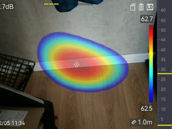
Moisture buildup, air leaks and thermal bridges are among the most common and costly building envelope defects, causing structural damage, increased energy consumption and mold growth inside walls. Infrared thermography is often used to detect and determine the extent of these defects, and can also be used to detect thermal bridges, lack of wall insulation, window or door installation defects.
The construction industry has been using portable infrared cameras to assess buildings for many years. However, developments in drone technology have made thermal imaging safer, more cost-effective and more accessible in challenging conditions. These approaches have also improved data clarity and expanded the possible range of applications for thermal imaging. Traditional methods of direct inspection from the ground or using elevators have their limitations, which drones can eliminate.
In addition to inspecting thermal defects in buildings, drones are being used to monitor various infrastructure components, such as bridges, roads and power lines. Thermal imaging cameras can detect excessive heating of structural components, which can indicate potential damage or performance problems. In addition, drones can be used to inspect technical installations, such as high-voltage lines or industrial facilities. Allowing for quick detection of problems, making it easier to schedule maintenance and repairs.
Benefits of drones with 4K and thermal imaging cameras
Time and cost efficiency
Infrared roof scans with portable cameras are performed from roof level sometimes on a ladder, which not only involves long survey times, but also safety risks. While a camera mounted on a drone can capture the same area in a few minutes.
Environmental Parameters
The use of a drone with a thermal imaging camera provides a wide field of view, and the surface temperature is shown in relation to neighboring materials over a larger area, minimizing the effect of small differences in surface temperature and revealing more extensive thermal anomalies associated with damp roofing materials or air leakage. This allows thermograms to be taken over a wider field of view.
Reflections
Infrared images are most accurate when taken perpendicular to the surface being scanned to avoid ambient reflections that can cover up or distort thermal anomalies associated with water or air leakage. A drone-mounted camera offers greater flexibility, allowing photographs to be taken from different distances and angles.
Data quality
With a 4K camera, the drones can provide high-quality bird’s-eye images, enabling accurate assessment of the condition of objects.
Mobility and Accessibility
Drones can easily reach hard-to-reach areas, such as rooftops or high-altitude areas, providing comprehensive aerial coverage. This makes it possible to scan areas that are difficult to reach with traditional methods.
The use of drones equipped with advanced thermal imaging and 4K cameras is changing the way thermal imaging surveys and building inspections are conducted. Drones enable fast, accurate and safe collection of field data, resulting in better investment decision-making and resource management. The prospects for this technology are promising, and further drone innovations are sure to bring even more benefits to the construction industry and other sectors where thermal imaging surveys are crucial to keeping infrastructure in good condition.

Figure 1 Real band image from a drone raid

Figure 2 Real band image from a drone raid
Figure 3 Real band image from a drone raid
Figure 4 Real band image from a drone raid